|
|
| Point ID: 72 | Downloads | Plots | Site Data | Code: 05AC027 |
|
| Download | |
|---|---|
| Site Descriptor Information | Site Time Series Data |
| Link to all available data | |
|
|
|
| View: | Statistics | All |
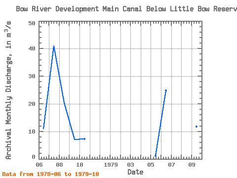
| Units: | mm |
| Year | Jan | Feb | Mar | Apr | May | Jun | Jul | Aug | Sep | Oct | Nov | Dec | Annual | 1978 | 11.00 | 41.00 | 20.30 | 7.07 | 7.29 | 1979 | 1.19 | 24.80 | 45.40 | 21.80 | 11.80 | 7.43 |
|---|
 Return to R-Arctic Net Home Page