|
|
|||||||||||||||||
| Point ID: 7192 | Downloads | Plots | Site Data | Code: 12157 |
|
|
|||||||||||||||||
| Download | |
|---|---|
| Site Descriptor Information | Site Time Series Data |
| Link to all available data | |
| View: | Time Series | All |
| Units: | mm |
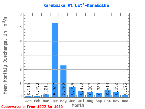
| Statistic | Jan | Feb | Mar | Apr | May | Jun | Jul | Aug | Sep | Oct | Nov | Dec | Annual |
|---|---|---|---|---|---|---|---|---|---|---|---|---|---|
| Mean | 0.12 | 0.09 | 0.21 | 5.31 | 2.26 | 0.73 | 0.47 | 0.39 | 0.33 | 0.51 | 0.39 | 0.17 | 0.95 |
| Standard Deviation | 0.08 | 0.06 | 0.23 | 3.58 | 1.82 | 0.51 | 0.59 | 0.45 | 0.33 | 0.54 | 0.34 | 0.15 | 0.49 |
| Min | 0.02 | 0.02 | 0.02 | 0.15 | 0.12 | 0.05 | 0.03 | 0.02 | 0.02 | 0.02 | 0.01 | 0.00 | 0.10 |
| Max | 0.33 | 0.20 | 0.86 | 12.70 | 6.49 | 1.89 | 2.95 | 1.68 | 1.39 | 2.62 | 1.51 | 0.62 | 1.88 |
| Coefficient of Variation | 0.67 | 0.60 | 1.09 | 0.68 | 0.80 | 0.69 | 1.25 | 1.15 | 0.99 | 1.06 | 0.88 | 0.84 | 0.52 |
 Return to R-Arctic Net Home Page