|
|
|||||||||||||||||
| Point ID: 7192 | Downloads | Plots | Site Data | Code: 12157 |
|
|
|||||||||||||||||
| Download | |
|---|---|
| Site Descriptor Information | Site Time Series Data |
| Link to all available data | |
| View: | Time Series | All |
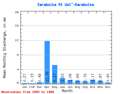
| Units: | m3/s |
| Statistic | Jan | Feb | Mar | Apr | May | Jun | Jul | Aug | Sep | Oct | Nov | Dec | Annual |
|---|---|---|---|---|---|---|---|---|---|---|---|---|---|
| Mean | 0.27 | 0.19 | 0.48 | 11.76 | 5.17 | 1.62 | 1.07 | 0.89 | 0.73 | 1.18 | 0.87 | 0.40 | 25.56 |
| Standard Deviation | 0.18 | 0.12 | 0.53 | 7.94 | 4.16 | 1.13 | 1.34 | 1.02 | 0.73 | 1.24 | 0.76 | 0.34 | 13.27 |
| Min | 0.05 | 0.03 | 0.05 | 0.33 | 0.28 | 0.11 | 0.06 | 0.04 | 0.04 | 0.04 | 0.03 | 0.01 | 2.60 |
| Max | 0.76 | 0.42 | 1.97 | 28.14 | 14.86 | 4.19 | 6.75 | 3.84 | 3.08 | 6.00 | 3.34 | 1.42 | 50.82 |
| Coefficient of Variation | 0.67 | 0.60 | 1.09 | 0.68 | 0.80 | 0.69 | 1.25 | 1.15 | 0.99 | 1.06 | 0.88 | 0.84 | 0.52 |
 Return to R-Arctic Net Home Page