|
|
|||||||||||||||||
| Point ID: 7183 | Downloads | Plots | Site Data | Code: 12125 |
|
|
|||||||||||||||||
| Download | |
|---|---|
| Site Descriptor Information | Site Time Series Data |
| Link to all available data | |
| View: | Time Series | All |
| Units: | mm |
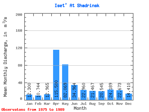
| Statistic | Jan | Feb | Mar | Apr | May | Jun | Jul | Aug | Sep | Oct | Nov | Dec | Annual |
|---|---|---|---|---|---|---|---|---|---|---|---|---|---|
| Mean | 12.30 | 10.74 | 12.96 | 115.50 | 82.07 | 34.96 | 22.96 | 21.47 | 20.55 | 24.19 | 22.67 | 14.41 | 33.19 |
| Standard Deviation | 5.83 | 4.44 | 5.28 | 76.03 | 54.08 | 18.05 | 12.70 | 10.92 | 8.63 | 17.20 | 17.91 | 6.17 | 14.25 |
| Min | 3.34 | 4.17 | 5.98 | 21.90 | 14.40 | 7.83 | 8.17 | 8.27 | 8.79 | 7.75 | 4.38 | 4.04 | 11.75 |
| Max | 24.10 | 18.30 | 22.30 | 266.00 | 168.00 | 61.70 | 56.90 | 43.80 | 38.90 | 59.60 | 70.10 | 26.70 | 56.57 |
| Coefficient of Variation | 0.47 | 0.41 | 0.41 | 0.66 | 0.66 | 0.52 | 0.55 | 0.51 | 0.42 | 0.71 | 0.79 | 0.43 | 0.43 |
 Return to R-Arctic Net Home Page