|
|
|||||||||||||||||
| Point ID: 7183 | Downloads | Plots | Site Data | Code: 12125 |
|
|
|||||||||||||||||
| Download | |
|---|---|
| Site Descriptor Information | Site Time Series Data |
| Link to all available data | |
| View: | Time Series | All |
| Units: | m3/s |
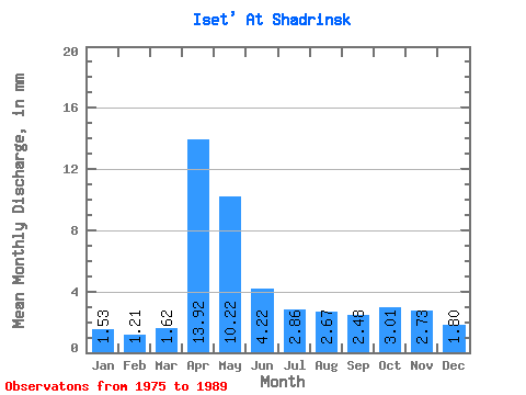
| Statistic | Jan | Feb | Mar | Apr | May | Jun | Jul | Aug | Sep | Oct | Nov | Dec | Annual |
|---|---|---|---|---|---|---|---|---|---|---|---|---|---|
| Mean | 1.41 | 1.12 | 1.48 | 12.79 | 9.39 | 3.87 | 2.63 | 2.46 | 2.28 | 2.77 | 2.51 | 1.65 | 44.76 |
| Standard Deviation | 0.67 | 0.46 | 0.60 | 8.42 | 6.19 | 2.00 | 1.45 | 1.25 | 0.96 | 1.97 | 1.98 | 0.71 | 19.21 |
| Min | 0.38 | 0.43 | 0.68 | 2.43 | 1.65 | 0.87 | 0.94 | 0.95 | 0.97 | 0.89 | 0.48 | 0.46 | 15.85 |
| Max | 2.76 | 1.91 | 2.55 | 29.46 | 19.23 | 6.83 | 6.51 | 5.01 | 4.31 | 6.82 | 7.76 | 3.06 | 76.29 |
| Coefficient of Variation | 0.47 | 0.41 | 0.41 | 0.66 | 0.66 | 0.52 | 0.55 | 0.51 | 0.42 | 0.71 | 0.79 | 0.43 | 0.43 |
 Return to R-Arctic Net Home Page