|
|
|||||||||||||||||
| Point ID: 7122 | Downloads | Plots | Site Data | Code: 11586 |
|
|
|||||||||||||||||
| Download | |
|---|---|
| Site Descriptor Information | Site Time Series Data |
| Link to all available data | |
| View: | Time Series | All |
| Units: | mm |
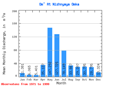
| Statistic | Jan | Feb | Mar | Apr | May | Jun | Jul | Aug | Sep | Oct | Nov | Dec | Annual |
|---|---|---|---|---|---|---|---|---|---|---|---|---|---|
| Mean | 11.38 | 6.07 | 5.40 | 35.14 | 147.29 | 127.72 | 78.15 | 33.87 | 29.40 | 30.80 | 28.80 | 13.32 | 48.34 |
| Standard Deviation | 19.11 | 3.48 | 2.75 | 22.53 | 71.96 | 126.65 | 129.86 | 63.02 | 44.69 | 39.98 | 34.95 | 12.08 | 38.86 |
| Min | 2.49 | 2.03 | 1.92 | 9.99 | 33.60 | 0.03 | 0.24 | 0.02 | 4.45 | 5.57 | 3.15 | 2.70 | 8.61 |
| Max | 100.00 | 16.90 | 12.20 | 89.80 | 260.00 | 415.00 | 541.00 | 281.00 | 201.00 | 162.00 | 148.00 | 45.70 | 146.88 |
| Coefficient of Variation | 1.68 | 0.57 | 0.51 | 0.64 | 0.49 | 0.99 | 1.66 | 1.86 | 1.52 | 1.30 | 1.21 | 0.91 | 0.80 |
 Return to R-Arctic Net Home Page