|
|
|||||||||||||||||
| Point ID: 7122 | Downloads | Plots | Site Data | Code: 11586 |
|
|
|||||||||||||||||
| Download | |
|---|---|
| Site Descriptor Information | Site Time Series Data |
| Link to all available data | |
| View: | Time Series | All |
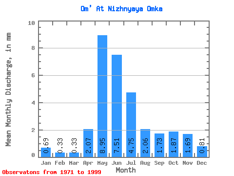
| Units: | m3/s |
| Statistic | Jan | Feb | Mar | Apr | May | Jun | Jul | Aug | Sep | Oct | Nov | Dec | Annual |
|---|---|---|---|---|---|---|---|---|---|---|---|---|---|
| Mean | 0.69 | 0.34 | 0.33 | 2.06 | 8.94 | 7.51 | 4.75 | 2.06 | 1.73 | 1.87 | 1.69 | 0.81 | 34.59 |
| Standard Deviation | 1.16 | 0.19 | 0.17 | 1.32 | 4.37 | 7.44 | 7.89 | 3.83 | 2.63 | 2.43 | 2.05 | 0.73 | 27.81 |
| Min | 0.15 | 0.11 | 0.12 | 0.59 | 2.04 | 0.00 | 0.01 | 0.00 | 0.26 | 0.34 | 0.18 | 0.16 | 6.17 |
| Max | 6.07 | 0.94 | 0.74 | 5.28 | 15.79 | 24.39 | 32.85 | 17.06 | 11.81 | 9.84 | 8.70 | 2.77 | 105.11 |
| Coefficient of Variation | 1.68 | 0.57 | 0.51 | 0.64 | 0.49 | 0.99 | 1.66 | 1.86 | 1.52 | 1.30 | 1.21 | 0.91 | 0.80 |
 Return to R-Arctic Net Home Page