|
|
|||||||||||||||||
| Point ID: 7116 | Downloads | Plots | Site Data | Code: 11571 |
|
|
|||||||||||||||||
| Download | |
|---|---|
| Site Descriptor Information | Site Time Series Data |
| Link to all available data | |
| View: | Time Series | All |
| Units: | mm |
| Statistic | Jan | Feb | Mar | Apr | May | Jun | Jul | Aug | Sep | Oct | Nov | Dec | Annual |
|---|---|---|---|---|---|---|---|---|---|---|---|---|---|
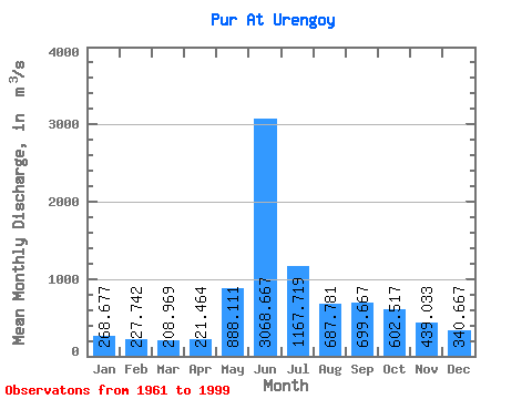
| Mean | 268.68 | 227.74 | 208.97 | 221.46 | 888.11 | 3068.67 | 1167.72 | 687.78 | 699.67 | 602.52 | 439.03 | 340.67 | 760.88 |
| Standard Deviation | 106.76 | 87.00 | 71.80 | 81.85 | 756.47 | 911.62 | 401.95 | 216.64 | 285.02 | 260.56 | 161.23 | 120.05 | 132.93 |
| Min | 137.00 | 131.00 | 131.00 | 128.00 | 171.00 | 1100.00 | 586.00 | 406.00 | 356.00 | 333.00 | 252.00 | 169.00 | 575.83 |
| Max | 613.00 | 557.00 | 493.00 | 445.00 | 2640.00 | 4460.00 | 2510.00 | 1170.00 | 1450.00 | 1380.00 | 898.00 | 700.00 | 999.67 |
| Coefficient of Variation | 0.40 | 0.38 | 0.34 | 0.37 | 0.85 | 0.30 | 0.34 | 0.32 | 0.41 | 0.43 | 0.37 | 0.35 | 0.17 |
 Return to R-Arctic Net Home Page