|
|
|||||||||||||||||
| Point ID: 7116 | Downloads | Plots | Site Data | Code: 11571 |
|
|
|||||||||||||||||
| Download | |
|---|---|
| Site Descriptor Information | Site Time Series Data |
| Link to all available data | |
| View: | Time Series | All |
| Units: | m3/s |
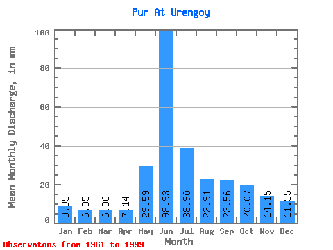
| Statistic | Jan | Feb | Mar | Apr | May | Jun | Jul | Aug | Sep | Oct | Nov | Dec | Annual |
|---|---|---|---|---|---|---|---|---|---|---|---|---|---|
| Mean | 8.95 | 6.91 | 6.96 | 7.14 | 29.58 | 98.93 | 38.90 | 22.91 | 22.56 | 20.07 | 14.15 | 11.35 | 298.67 |
| Standard Deviation | 3.56 | 2.64 | 2.39 | 2.64 | 25.20 | 29.39 | 13.39 | 7.22 | 9.19 | 8.68 | 5.20 | 4.00 | 52.18 |
| Min | 4.56 | 3.98 | 4.36 | 4.13 | 5.70 | 35.46 | 19.52 | 13.52 | 11.48 | 11.09 | 8.12 | 5.63 | 226.04 |
| Max | 20.42 | 16.90 | 16.42 | 14.35 | 87.93 | 143.78 | 83.60 | 38.97 | 46.75 | 45.97 | 28.95 | 23.32 | 392.41 |
| Coefficient of Variation | 0.40 | 0.38 | 0.34 | 0.37 | 0.85 | 0.30 | 0.34 | 0.32 | 0.41 | 0.43 | 0.37 | 0.35 | 0.17 |
 Return to R-Arctic Net Home Page