|
|
|||||||||||||||||
| Point ID: 7112 | Downloads | Plots | Site Data | Code: 11558 |
|
|
|||||||||||||||||
| Download | |
|---|---|
| Site Descriptor Information | Site Time Series Data |
| Link to all available data | |
| View: | Time Series | All |
| Units: | mm |
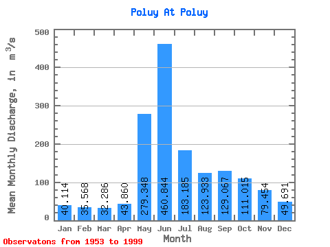
| Statistic | Jan | Feb | Mar | Apr | May | Jun | Jul | Aug | Sep | Oct | Nov | Dec | Annual |
|---|---|---|---|---|---|---|---|---|---|---|---|---|---|
| Mean | 40.11 | 35.57 | 32.29 | 43.86 | 279.35 | 460.84 | 183.19 | 123.93 | 129.07 | 111.02 | 79.45 | 49.69 | 132.32 |
| Standard Deviation | 6.76 | 5.74 | 4.61 | 40.12 | 185.51 | 215.21 | 72.30 | 67.55 | 55.52 | 36.73 | 60.85 | 8.80 | 23.48 |
| Min | 28.40 | 23.00 | 21.90 | 23.10 | 34.50 | 151.00 | 80.80 | 58.70 | 58.00 | 48.70 | 34.70 | 35.30 | 94.01 |
| Max | 66.70 | 51.60 | 39.60 | 268.00 | 772.00 | 842.00 | 366.00 | 433.00 | 276.00 | 199.00 | 466.00 | 69.90 | 225.97 |
| Coefficient of Variation | 0.17 | 0.16 | 0.14 | 0.92 | 0.66 | 0.47 | 0.40 | 0.55 | 0.43 | 0.33 | 0.77 | 0.18 | 0.18 |
 Return to R-Arctic Net Home Page