|
|
|||||||||||||||||
| Point ID: 7112 | Downloads | Plots | Site Data | Code: 11558 |
|
|
|||||||||||||||||
| Download | |
|---|---|
| Site Descriptor Information | Site Time Series Data |
| Link to all available data | |
| View: | Time Series | All |
| Units: | m3/s |
| Statistic | Jan | Feb | Mar | Apr | May | Jun | Jul | Aug | Sep | Oct | Nov | Dec | Annual |
|---|---|---|---|---|---|---|---|---|---|---|---|---|---|
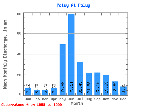
| Mean | 7.11 | 5.75 | 5.73 | 7.53 | 49.54 | 79.11 | 32.49 | 21.98 | 22.16 | 19.69 | 13.64 | 8.81 | 276.57 |
| Standard Deviation | 1.20 | 0.93 | 0.82 | 6.89 | 32.90 | 36.94 | 12.82 | 11.98 | 9.53 | 6.51 | 10.45 | 1.56 | 49.07 |
| Min | 5.04 | 3.72 | 3.88 | 3.96 | 6.12 | 25.92 | 14.33 | 10.41 | 9.96 | 8.64 | 5.96 | 6.26 | 196.48 |
| Max | 11.83 | 8.34 | 7.02 | 46.00 | 136.91 | 144.53 | 64.91 | 76.79 | 47.38 | 35.29 | 79.99 | 12.40 | 472.30 |
| Coefficient of Variation | 0.17 | 0.16 | 0.14 | 0.92 | 0.66 | 0.47 | 0.40 | 0.55 | 0.43 | 0.33 | 0.77 | 0.18 | 0.18 |
 Return to R-Arctic Net Home Page