|
|
|||||||||||||||||
| Point ID: 7111 | Downloads | Plots | Site Data | Code: 11557 |
|
|
|||||||||||||||||
| Download | |
|---|---|
| Site Descriptor Information | Site Time Series Data |
| Link to all available data | |
| View: | Time Series | All |
| Units: | mm |
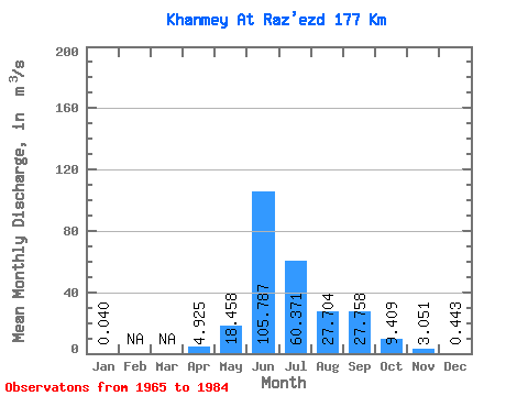
| Statistic | Jan | Feb | Mar | Apr | May | Jun | Jul | Aug | Sep | Oct | Nov | Dec | Annual |
|---|---|---|---|---|---|---|---|---|---|---|---|---|---|
| Mean | 0.04 | 4.92 | 18.46 | 105.79 | 60.37 | 27.70 | 27.76 | 9.41 | 3.05 | 0.44 | |||
| Standard Deviation | 0.04 | 5.56 | 27.79 | 21.62 | 24.46 | 17.58 | 17.51 | 4.60 | 1.86 | 0.65 | |||
| Min | 0.01 | 0.99 | 0.05 | 72.90 | 19.60 | 7.43 | 10.40 | 3.52 | 1.43 | 0.04 | |||
| Max | 0.07 | 8.86 | 95.40 | 159.00 | 101.00 | 68.90 | 71.00 | 18.00 | 7.80 | 2.24 | |||
| Coefficient of Variation | 1.02 | 1.13 | 1.51 | 0.20 | 0.41 | 0.64 | 0.63 | 0.49 | 0.61 | 1.46 |
 Return to R-Arctic Net Home Page