|
|
|||||||||||||||||
| Point ID: 7111 | Downloads | Plots | Site Data | Code: 11557 |
|
|
|||||||||||||||||
| Download | |
|---|---|
| Site Descriptor Information | Site Time Series Data |
| Link to all available data | |
| View: | Time Series | All |
| Units: | m3/s |
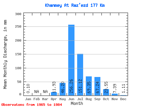
| Statistic | Jan | Feb | Mar | Apr | May | Jun | Jul | Aug | Sep | Oct | Nov | Dec | Annual |
|---|---|---|---|---|---|---|---|---|---|---|---|---|---|
| Mean | 0.10 | 11.93 | 46.20 | 256.26 | 151.10 | 69.34 | 67.24 | 23.55 | 7.39 | 1.11 | |||
| Standard Deviation | 0.10 | 13.48 | 69.56 | 52.37 | 61.22 | 44.01 | 42.41 | 11.51 | 4.50 | 1.62 | |||
| Min | 0.03 | 2.40 | 0.12 | 176.59 | 49.05 | 18.60 | 25.19 | 8.81 | 3.46 | 0.10 | |||
| Max | 0.17 | 21.46 | 238.77 | 385.17 | 252.78 | 172.44 | 171.99 | 45.05 | 18.89 | 5.61 | |||
| Coefficient of Variation | 1.02 | 1.13 | 1.51 | 0.20 | 0.41 | 0.64 | 0.63 | 0.49 | 0.61 | 1.46 |
 Return to R-Arctic Net Home Page