|
|
|||||||||||||||||
| Point ID: 7102 | Downloads | Plots | Site Data | Code: 11541 |
|
|
|||||||||||||||||
| Download | |
|---|---|
| Site Descriptor Information | Site Time Series Data |
| Link to all available data | |
| View: | Time Series | All |
| Units: | mm |
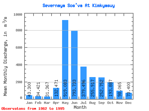
| Statistic | Jan | Feb | Mar | Apr | May | Jun | Jul | Aug | Sep | Oct | Nov | Dec | Annual |
|---|---|---|---|---|---|---|---|---|---|---|---|---|---|
| Mean | 43.30 | 34.42 | 31.37 | 132.47 | 919.08 | 793.73 | 379.50 | 255.92 | 252.75 | 193.89 | 98.06 | 73.40 | 265.93 |
| Standard Deviation | 12.87 | 10.77 | 9.30 | 255.19 | 307.42 | 416.71 | 252.19 | 201.61 | 148.15 | 113.43 | 37.14 | 65.39 | 67.21 |
| Min | 21.80 | 19.10 | 18.00 | 17.30 | 266.00 | 0.60 | 50.40 | 87.70 | 69.60 | 57.30 | 42.20 | 39.10 | 146.28 |
| Max | 77.50 | 66.00 | 51.10 | 1250.00 | 1430.00 | 1540.00 | 1030.00 | 946.00 | 534.00 | 554.00 | 164.00 | 366.00 | 393.12 |
| Coefficient of Variation | 0.30 | 0.31 | 0.30 | 1.93 | 0.33 | 0.53 | 0.67 | 0.79 | 0.59 | 0.58 | 0.38 | 0.89 | 0.25 |
 Return to R-Arctic Net Home Page