|
|
|||||||||||||||||
| Point ID: 7102 | Downloads | Plots | Site Data | Code: 11541 |
|
|
|||||||||||||||||
| Download | |
|---|---|
| Site Descriptor Information | Site Time Series Data |
| Link to all available data | |
| View: | Time Series | All |
| Units: | m3/s |
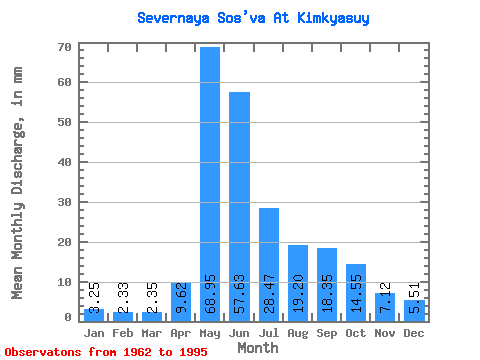
| Statistic | Jan | Feb | Mar | Apr | May | Jun | Jul | Aug | Sep | Oct | Nov | Dec | Annual |
|---|---|---|---|---|---|---|---|---|---|---|---|---|---|
| Mean | 3.25 | 2.35 | 2.35 | 9.62 | 68.94 | 57.63 | 28.47 | 19.20 | 18.35 | 14.54 | 7.12 | 5.51 | 235.09 |
| Standard Deviation | 0.96 | 0.74 | 0.70 | 18.53 | 23.06 | 30.25 | 18.92 | 15.12 | 10.76 | 8.51 | 2.70 | 4.91 | 59.41 |
| Min | 1.64 | 1.30 | 1.35 | 1.26 | 19.95 | 0.04 | 3.78 | 6.58 | 5.05 | 4.30 | 3.06 | 2.93 | 129.31 |
| Max | 5.81 | 4.51 | 3.83 | 90.76 | 107.27 | 111.81 | 77.26 | 70.96 | 38.77 | 41.56 | 11.91 | 27.45 | 347.53 |
| Coefficient of Variation | 0.30 | 0.31 | 0.30 | 1.93 | 0.33 | 0.53 | 0.67 | 0.79 | 0.59 | 0.58 | 0.38 | 0.89 | 0.25 |
 Return to R-Arctic Net Home Page