|
|
|||||||||||||||||
| Point ID: 7099 | Downloads | Plots | Site Data | Code: 11537 |
|
|
|||||||||||||||||
| Download | |
|---|---|
| Site Descriptor Information | Site Time Series Data |
| Link to all available data | |
| View: | Time Series | All |
| Units: | mm |
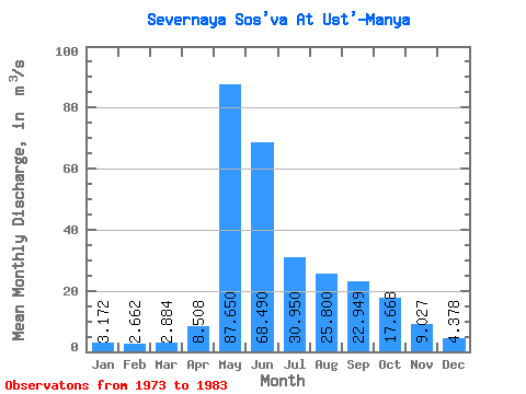
| Statistic | Jan | Feb | Mar | Apr | May | Jun | Jul | Aug | Sep | Oct | Nov | Dec | Annual |
|---|---|---|---|---|---|---|---|---|---|---|---|---|---|
| Mean | 3.17 | 2.66 | 2.88 | 8.51 | 87.65 | 68.49 | 30.95 | 25.80 | 22.95 | 17.67 | 9.03 | 4.38 | 24.94 |
| Standard Deviation | 0.97 | 0.81 | 1.03 | 8.58 | 30.15 | 40.19 | 14.17 | 20.38 | 14.97 | 10.41 | 4.03 | 1.50 | 4.92 |
| Min | 1.06 | 0.86 | 1.04 | 2.51 | 41.50 | 23.10 | 10.00 | 8.90 | 7.58 | 4.75 | 4.12 | 2.54 | 19.09 |
| Max | 4.34 | 4.06 | 4.71 | 22.70 | 130.00 | 143.00 | 56.90 | 75.50 | 53.50 | 33.70 | 15.20 | 6.87 | 30.66 |
| Coefficient of Variation | 0.30 | 0.30 | 0.36 | 1.01 | 0.34 | 0.59 | 0.46 | 0.79 | 0.65 | 0.59 | 0.45 | 0.34 | 0.20 |
 Return to R-Arctic Net Home Page