|
|
|||||||||||||||||
| Point ID: 7099 | Downloads | Plots | Site Data | Code: 11537 |
|
|
|||||||||||||||||
| Download | |
|---|---|
| Site Descriptor Information | Site Time Series Data |
| Link to all available data | |
| View: | Time Series | All |
| Units: | m3/s |
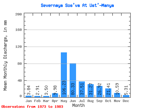
| Statistic | Jan | Feb | Mar | Apr | May | Jun | Jul | Aug | Sep | Oct | Nov | Dec | Annual |
|---|---|---|---|---|---|---|---|---|---|---|---|---|---|
| Mean | 3.84 | 2.94 | 3.50 | 9.98 | 106.21 | 80.33 | 37.50 | 31.26 | 26.92 | 21.41 | 10.59 | 5.30 | 356.16 |
| Standard Deviation | 1.17 | 0.90 | 1.25 | 10.07 | 36.53 | 47.14 | 17.17 | 24.69 | 17.56 | 12.61 | 4.72 | 1.82 | 70.27 |
| Min | 1.28 | 0.95 | 1.26 | 2.94 | 50.29 | 27.09 | 12.12 | 10.79 | 8.89 | 5.76 | 4.83 | 3.08 | 272.64 |
| Max | 5.26 | 4.48 | 5.71 | 26.62 | 157.53 | 167.72 | 68.95 | 91.49 | 62.75 | 40.84 | 17.83 | 8.32 | 437.78 |
| Coefficient of Variation | 0.30 | 0.30 | 0.36 | 1.01 | 0.34 | 0.59 | 0.46 | 0.79 | 0.65 | 0.59 | 0.45 | 0.34 | 0.20 |
 Return to R-Arctic Net Home Page