|
|
|||||||||||||||||
| Point ID: 7072 | Downloads | Plots | Site Data | Code: 11470 |
|
|
|||||||||||||||||
| Download | |
|---|---|
| Site Descriptor Information | Site Time Series Data |
| Link to all available data | |
| View: | Time Series | All |
| Units: | mm |
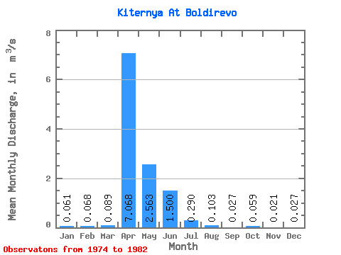
| Statistic | Jan | Feb | Mar | Apr | May | Jun | Jul | Aug | Sep | Oct | Nov | Dec | Annual |
|---|---|---|---|---|---|---|---|---|---|---|---|---|---|
| Mean | 0.06 | 0.07 | 0.09 | 7.07 | 2.56 | 1.50 | 0.29 | 0.10 | 0.03 | 0.06 | 0.02 | 0.03 | |
| Standard Deviation | 0.01 | 0.01 | 0.01 | 4.48 | 2.18 | 0.27 | 0.14 | 0.02 | 0.02 | 0.02 | |||
| Min | 0.05 | 0.06 | 0.08 | 3.54 | 0.01 | 1.31 | 0.19 | 0.09 | 0.03 | 0.06 | 0.01 | 0.01 | |
| Max | 0.07 | 0.08 | 0.10 | 13.60 | 5.95 | 1.69 | 0.39 | 0.12 | 0.03 | 0.06 | 0.03 | 0.04 | |
| Coefficient of Variation | 0.21 | 0.21 | 0.14 | 0.63 | 0.85 | 0.18 | 0.49 | 0.23 | 0.79 | 0.84 |
 Return to R-Arctic Net Home Page