|
|
|||||||||||||||||
| Point ID: 7072 | Downloads | Plots | Site Data | Code: 11470 |
|
|
|||||||||||||||||
| Download | |
|---|---|
| Site Descriptor Information | Site Time Series Data |
| Link to all available data | |
| View: | Time Series | All |
| Units: | m3/s |
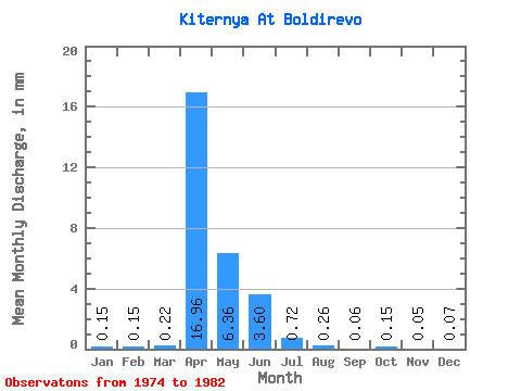
| Statistic | Jan | Feb | Mar | Apr | May | Jun | Jul | Aug | Sep | Oct | Nov | Dec | Annual |
|---|---|---|---|---|---|---|---|---|---|---|---|---|---|
| Mean | 0.15 | 0.15 | 0.22 | 16.96 | 6.36 | 3.60 | 0.72 | 0.26 | 0.07 | 0.15 | 0.05 | 0.07 | |
| Standard Deviation | 0.03 | 0.03 | 0.03 | 10.75 | 5.41 | 0.65 | 0.35 | 0.06 | 0.04 | 0.06 | |||
| Min | 0.13 | 0.13 | 0.19 | 8.50 | 0.03 | 3.14 | 0.47 | 0.21 | 0.07 | 0.15 | 0.02 | 0.03 | |
| Max | 0.17 | 0.19 | 0.25 | 32.64 | 14.75 | 4.06 | 0.97 | 0.30 | 0.07 | 0.15 | 0.08 | 0.11 | |
| Coefficient of Variation | 0.21 | 0.21 | 0.14 | 0.63 | 0.85 | 0.18 | 0.49 | 0.23 | 0.79 | 0.84 |
 Return to R-Arctic Net Home Page