|
|
|||||||||||||||||
| Point ID: 7060 | Downloads | Plots | Site Data | Code: 11423 |
|
|
|||||||||||||||||
| Download | |
|---|---|
| Site Descriptor Information | Site Time Series Data |
| Link to all available data | |
| View: | Time Series | All |
| Units: | mm |
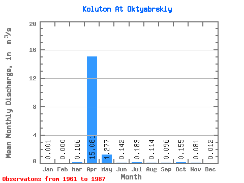
| Statistic | Jan | Feb | Mar | Apr | May | Jun | Jul | Aug | Sep | Oct | Nov | Dec | Annual |
|---|---|---|---|---|---|---|---|---|---|---|---|---|---|
| Mean | 0.00 | 0.00 | 0.19 | 15.08 | 1.28 | 0.14 | 0.18 | 0.11 | 0.10 | 0.15 | 0.08 | 0.01 | 3.33 |
| Standard Deviation | 0.00 | 0.00 | 0.25 | 16.54 | 1.57 | 0.13 | 0.42 | 0.11 | 0.05 | 0.10 | 0.06 | 0.01 | |
| Min | 0.00 | 0.00 | 0.00 | 0.91 | 0.09 | 0.01 | 0.01 | 0.02 | 0.02 | 0.03 | 0.00 | 0.00 | 3.33 |
| Max | 0.00 | 0.00 | 0.65 | 58.10 | 6.05 | 0.52 | 2.04 | 0.55 | 0.26 | 0.46 | 0.22 | 0.04 | 3.33 |
| Coefficient of Variation | 1.20 | 1.34 | 1.10 | 1.23 | 0.89 | 2.29 | 0.94 | 0.51 | 0.64 | 0.68 | 0.99 |
 Return to R-Arctic Net Home Page