|
|
|||||||||||||||||
| Point ID: 7060 | Downloads | Plots | Site Data | Code: 11423 |
|
|
|||||||||||||||||
| Download | |
|---|---|
| Site Descriptor Information | Site Time Series Data |
| Link to all available data | |
| View: | Time Series | All |
| Units: | m3/s |
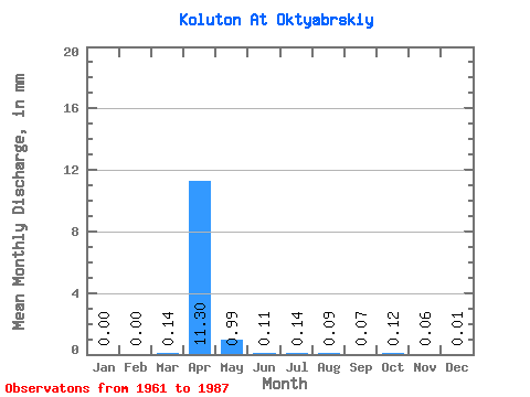
| Statistic | Jan | Feb | Mar | Apr | May | Jun | Jul | Aug | Sep | Oct | Nov | Dec | Annual |
|---|---|---|---|---|---|---|---|---|---|---|---|---|---|
| Mean | 0.00 | 0.00 | 0.14 | 11.30 | 0.99 | 0.11 | 0.14 | 0.09 | 0.07 | 0.12 | 0.06 | 0.01 | 30.42 |
| Standard Deviation | 0.00 | 0.00 | 0.19 | 12.39 | 1.22 | 0.09 | 0.32 | 0.08 | 0.04 | 0.08 | 0.04 | 0.01 | |
| Min | 0.00 | 0.00 | 0.00 | 0.68 | 0.07 | 0.01 | 0.01 | 0.01 | 0.02 | 0.03 | 0.00 | 0.00 | 30.42 |
| Max | 0.00 | 0.00 | 0.50 | 43.52 | 4.68 | 0.39 | 1.58 | 0.43 | 0.20 | 0.36 | 0.17 | 0.03 | 30.42 |
| Coefficient of Variation | 1.20 | 1.34 | 1.10 | 1.23 | 0.89 | 2.29 | 0.94 | 0.51 | 0.64 | 0.68 | 0.99 |
 Return to R-Arctic Net Home Page