|
|
|||||||||||||||||
| Point ID: 704 | Downloads | Plots | Site Data | Code: 07DA005 |
|
|
|||||||||||||||||
| Download | |
|---|---|
| Site Descriptor Information | Site Time Series Data |
| Link to all available data | |
| View: | Time Series | All |
| Units: | mm |
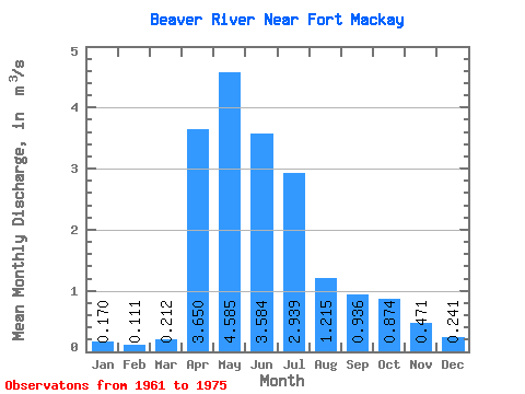
| Statistic | Jan | Feb | Mar | Apr | May | Jun | Jul | Aug | Sep | Oct | Nov | Dec | Annual |
|---|---|---|---|---|---|---|---|---|---|---|---|---|---|
| Mean | 0.17 | 0.11 | 0.21 | 3.65 | 4.58 | 3.58 | 2.94 | 1.22 | 0.94 | 0.87 | 0.47 | 0.24 | 1.97 |
| Standard Deviation | 0.04 | 0.02 | 0.19 | 2.82 | 3.41 | 2.77 | 2.53 | 1.21 | 0.96 | 0.59 | 0.17 | 0.12 | 0.26 |
| Min | 0.12 | 0.09 | 0.07 | 1.00 | 1.61 | 1.55 | 0.51 | 0.16 | 0.19 | 0.27 | 0.29 | 0.07 | 1.74 |
| Max | 0.20 | 0.13 | 0.49 | 7.53 | 9.40 | 9.40 | 7.84 | 3.55 | 3.35 | 2.00 | 0.71 | 0.36 | 2.25 |
| Coefficient of Variation | 0.24 | 0.20 | 0.91 | 0.77 | 0.74 | 0.77 | 0.86 | 0.99 | 1.03 | 0.68 | 0.37 | 0.52 | 0.13 |
 Return to R-Arctic Net Home Page