|
|
|||||||||||||||||
| Point ID: 704 | Downloads | Plots | Site Data | Code: 07DA005 |
|
|
|||||||||||||||||
| Download | |
|---|---|
| Site Descriptor Information | Site Time Series Data |
| Link to all available data | |
| View: | Time Series | All |
| Units: | m3/s |
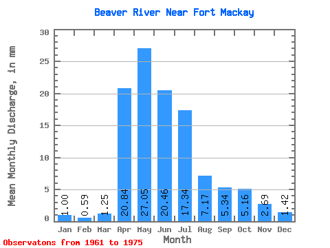
| Statistic | Jan | Feb | Mar | Apr | May | Jun | Jul | Aug | Sep | Oct | Nov | Dec | Annual |
|---|---|---|---|---|---|---|---|---|---|---|---|---|---|
| Mean | 1.00 | 0.59 | 1.25 | 20.84 | 27.05 | 20.46 | 17.34 | 7.17 | 5.34 | 5.16 | 2.69 | 1.42 | 136.91 |
| Standard Deviation | 0.24 | 0.12 | 1.14 | 16.11 | 20.14 | 15.81 | 14.94 | 7.11 | 5.49 | 3.50 | 1.00 | 0.73 | 18.23 |
| Min | 0.73 | 0.48 | 0.43 | 5.71 | 9.50 | 8.85 | 3.00 | 0.93 | 1.11 | 1.58 | 1.66 | 0.40 | 120.97 |
| Max | 1.20 | 0.71 | 2.91 | 42.99 | 55.45 | 53.67 | 46.25 | 20.94 | 19.13 | 11.80 | 4.05 | 2.13 | 156.78 |
| Coefficient of Variation | 0.24 | 0.20 | 0.91 | 0.77 | 0.74 | 0.77 | 0.86 | 0.99 | 1.03 | 0.68 | 0.37 | 0.52 | 0.13 |
 Return to R-Arctic Net Home Page