|
|
|||||||||||||||||
| Point ID: 702 | Downloads | Plots | Site Data | Code: 07CE006 |
|
|
|||||||||||||||||
| Download | |
|---|---|
| Site Descriptor Information | Site Time Series Data |
| Link to all available data | |
| View: | Time Series | All |
| Units: | mm |
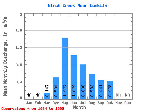
| Statistic | Jan | Feb | Mar | Apr | May | Jun | Jul | Aug | Sep | Oct | Nov | Dec | Annual |
|---|---|---|---|---|---|---|---|---|---|---|---|---|---|
| Mean | 0.15 | 0.50 | 1.43 | 1.02 | 0.81 | 0.58 | 0.44 | 0.43 | |||||
| Standard Deviation | 0.07 | 0.47 | 1.82 | 0.67 | 0.92 | 0.70 | 0.34 | 0.24 | |||||
| Min | 0.00 | 0.05 | 0.16 | 0.15 | 0.17 | 0.13 | 0.17 | 0.22 | |||||
| Max | 0.25 | 1.52 | 6.38 | 2.40 | 3.58 | 2.29 | 1.39 | 1.05 | |||||
| Coefficient of Variation | 0.51 | 0.93 | 1.28 | 0.65 | 1.14 | 1.20 | 0.76 | 0.57 |
 Return to R-Arctic Net Home Page