|
|
|||||||||||||||||
| Point ID: 702 | Downloads | Plots | Site Data | Code: 07CE006 |
|
|
|||||||||||||||||
| Download | |
|---|---|
| Site Descriptor Information | Site Time Series Data |
| Link to all available data | |
| View: | Time Series | All |
| Units: | m3/s |
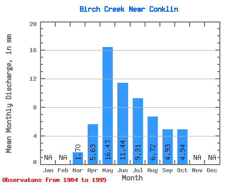
| Statistic | Jan | Feb | Mar | Apr | May | Jun | Jul | Aug | Sep | Oct | Nov | Dec | Annual |
|---|---|---|---|---|---|---|---|---|---|---|---|---|---|
| Mean | 1.70 | 5.64 | 16.47 | 11.44 | 9.31 | 6.71 | 4.92 | 4.94 | |||||
| Standard Deviation | 0.87 | 5.25 | 21.02 | 7.46 | 10.62 | 8.06 | 3.76 | 2.81 | |||||
| Min | 0.05 | 0.56 | 1.85 | 1.63 | 2.02 | 1.48 | 1.84 | 2.59 | |||||
| Max | 2.86 | 16.98 | 73.64 | 26.81 | 41.32 | 26.43 | 15.53 | 12.12 | |||||
| Coefficient of Variation | 0.51 | 0.93 | 1.28 | 0.65 | 1.14 | 1.20 | 0.76 | 0.57 |
 Return to R-Arctic Net Home Page