|
|
|||||||||||||||||
| Point ID: 6992 | Downloads | Plots | Site Data | Code: 11234 |
|
|
|||||||||||||||||
| Download | |
|---|---|
| Site Descriptor Information | Site Time Series Data |
| Link to all available data | |
| View: | Time Series | All |
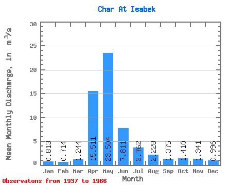
| Units: | mm |
| Statistic | Jan | Feb | Mar | Apr | May | Jun | Jul | Aug | Sep | Oct | Nov | Dec | Annual |
|---|---|---|---|---|---|---|---|---|---|---|---|---|---|
| Mean | 0.81 | 0.71 | 1.24 | 15.51 | 23.50 | 7.81 | 3.76 | 2.23 | 1.38 | 1.41 | 1.34 | 1.00 | 5.16 |
| Standard Deviation | 0.49 | 0.41 | 1.06 | 10.77 | 19.79 | 7.06 | 3.82 | 3.78 | 1.52 | 1.09 | 1.09 | 0.94 | 4.20 |
| Min | 0.19 | 0.17 | 0.23 | 3.02 | 2.83 | 1.66 | 0.48 | 0.15 | 0.19 | 0.43 | 0.46 | 0.21 | 1.70 |
| Max | 1.87 | 1.44 | 3.85 | 46.10 | 97.70 | 34.10 | 14.70 | 17.50 | 6.90 | 5.08 | 4.55 | 3.74 | 17.70 |
| Coefficient of Variation | 0.60 | 0.57 | 0.85 | 0.69 | 0.84 | 0.90 | 1.02 | 1.70 | 1.11 | 0.78 | 0.81 | 0.94 | 0.81 |
 Return to R-Arctic Net Home Page