|
|
|||||||||||||||||
| Point ID: 6992 | Downloads | Plots | Site Data | Code: 11234 |
|
|
|||||||||||||||||
| Download | |
|---|---|
| Site Descriptor Information | Site Time Series Data |
| Link to all available data | |
| View: | Time Series | All |
| Units: | m3/s |
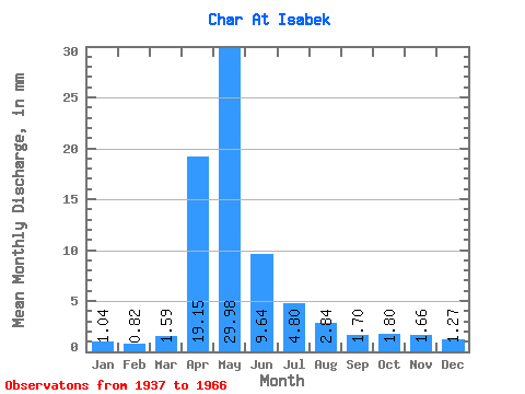
| Statistic | Jan | Feb | Mar | Apr | May | Jun | Jul | Aug | Sep | Oct | Nov | Dec | Annual |
|---|---|---|---|---|---|---|---|---|---|---|---|---|---|
| Mean | 1.04 | 0.83 | 1.59 | 19.14 | 29.97 | 9.64 | 4.80 | 2.84 | 1.70 | 1.80 | 1.66 | 1.27 | 77.60 |
| Standard Deviation | 0.63 | 0.47 | 1.35 | 13.29 | 25.23 | 8.71 | 4.87 | 4.83 | 1.88 | 1.39 | 1.34 | 1.20 | 63.10 |
| Min | 0.24 | 0.20 | 0.29 | 3.73 | 3.61 | 2.05 | 0.61 | 0.19 | 0.23 | 0.55 | 0.57 | 0.27 | 25.57 |
| Max | 2.38 | 1.67 | 4.91 | 56.90 | 124.59 | 42.09 | 18.75 | 22.32 | 8.52 | 6.48 | 5.62 | 4.77 | 265.97 |
| Coefficient of Variation | 0.60 | 0.57 | 0.85 | 0.69 | 0.84 | 0.90 | 1.02 | 1.70 | 1.11 | 0.78 | 0.81 | 0.94 | 0.81 |
 Return to R-Arctic Net Home Page