|
|
|||||||||||||||||
| Point ID: 6991 | Downloads | Plots | Site Data | Code: 11233 |
|
|
|||||||||||||||||
| Download | |
|---|---|
| Site Descriptor Information | Site Time Series Data |
| Link to all available data | |
| View: | Time Series | All |
| Units: | mm |
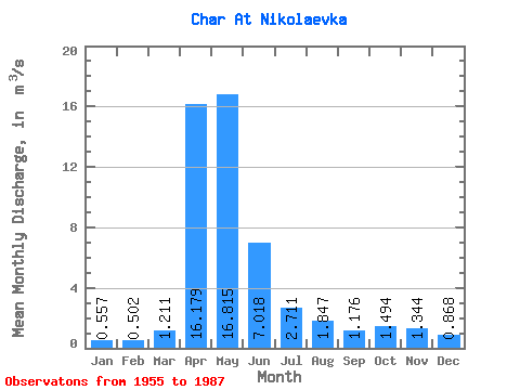
| Statistic | Jan | Feb | Mar | Apr | May | Jun | Jul | Aug | Sep | Oct | Nov | Dec | Annual |
|---|---|---|---|---|---|---|---|---|---|---|---|---|---|
| Mean | 0.56 | 0.50 | 1.21 | 16.18 | 16.82 | 7.02 | 2.71 | 1.85 | 1.18 | 1.49 | 1.34 | 0.87 | 4.36 |
| Standard Deviation | 0.44 | 0.38 | 1.44 | 10.60 | 13.53 | 6.59 | 2.55 | 3.02 | 1.23 | 0.97 | 1.02 | 0.77 | 2.60 |
| Min | 0.01 | 0.02 | 0.03 | 2.89 | 2.77 | 0.74 | 0.20 | 0.17 | 0.21 | 0.39 | 0.23 | 0.01 | 1.13 |
| Max | 1.88 | 1.98 | 7.69 | 41.20 | 59.10 | 32.60 | 11.30 | 17.00 | 6.41 | 4.17 | 4.05 | 3.65 | 13.37 |
| Coefficient of Variation | 0.79 | 0.75 | 1.19 | 0.66 | 0.81 | 0.94 | 0.94 | 1.64 | 1.04 | 0.65 | 0.76 | 0.88 | 0.59 |
 Return to R-Arctic Net Home Page