|
|
|||||||||||||||||
| Point ID: 6991 | Downloads | Plots | Site Data | Code: 11233 |
|
|
|||||||||||||||||
| Download | |
|---|---|
| Site Descriptor Information | Site Time Series Data |
| Link to all available data | |
| View: | Time Series | All |
| Units: | m3/s |
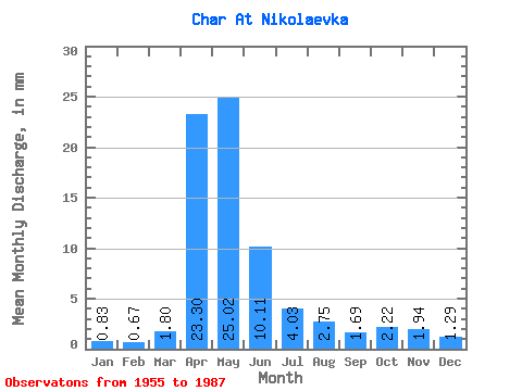
| Statistic | Jan | Feb | Mar | Apr | May | Jun | Jul | Aug | Sep | Oct | Nov | Dec | Annual |
|---|---|---|---|---|---|---|---|---|---|---|---|---|---|
| Mean | 0.83 | 0.68 | 1.80 | 23.30 | 25.02 | 10.11 | 4.03 | 2.75 | 1.69 | 2.22 | 1.94 | 1.29 | 76.45 |
| Standard Deviation | 0.65 | 0.51 | 2.13 | 15.27 | 20.13 | 9.49 | 3.79 | 4.50 | 1.77 | 1.44 | 1.47 | 1.14 | 45.52 |
| Min | 0.02 | 0.03 | 0.05 | 4.16 | 4.12 | 1.07 | 0.30 | 0.25 | 0.30 | 0.58 | 0.33 | 0.02 | 19.83 |
| Max | 2.80 | 2.68 | 11.44 | 59.33 | 87.93 | 46.94 | 16.81 | 25.29 | 9.23 | 6.20 | 5.83 | 5.43 | 234.46 |
| Coefficient of Variation | 0.79 | 0.75 | 1.19 | 0.66 | 0.81 | 0.94 | 0.94 | 1.64 | 1.04 | 0.65 | 0.76 | 0.88 | 0.59 |
 Return to R-Arctic Net Home Page