|
|
|||||||||||||||||
| Point ID: 6990 | Downloads | Plots | Site Data | Code: 11230 |
|
|
|||||||||||||||||
| Download | |
|---|---|
| Site Descriptor Information | Site Time Series Data |
| Link to all available data | |
| View: | Time Series | All |
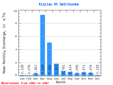
| Units: | mm |
| Statistic | Jan | Feb | Mar | Apr | May | Jun | Jul | Aug | Sep | Oct | Nov | Dec | Annual |
|---|---|---|---|---|---|---|---|---|---|---|---|---|---|
| Mean | 0.14 | 0.08 | 0.37 | 9.25 | 5.07 | 1.86 | 0.78 | 0.61 | 0.40 | 0.57 | 0.47 | 0.13 | 1.53 |
| Standard Deviation | 0.28 | 0.16 | 0.41 | 8.30 | 4.27 | 1.48 | 0.75 | 0.50 | 0.43 | 0.61 | 0.35 | 0.10 | 1.15 |
| Min | 0.00 | 0.00 | 0.00 | 1.42 | 0.98 | 0.10 | 0.04 | 0.00 | 0.00 | 0.07 | 0.06 | 0.00 | 0.40 |
| Max | 1.00 | 0.43 | 1.35 | 33.60 | 17.10 | 5.63 | 2.64 | 1.78 | 1.83 | 2.85 | 1.75 | 0.32 | 3.30 |
| Coefficient of Variation | 2.06 | 2.08 | 1.13 | 0.90 | 0.84 | 0.79 | 0.96 | 0.81 | 1.10 | 1.07 | 0.74 | 0.73 | 0.75 |
 Return to R-Arctic Net Home Page