|
|
|||||||||||||||||
| Point ID: 6990 | Downloads | Plots | Site Data | Code: 11230 |
|
|
|||||||||||||||||
| Download | |
|---|---|
| Site Descriptor Information | Site Time Series Data |
| Link to all available data | |
| View: | Time Series | All |
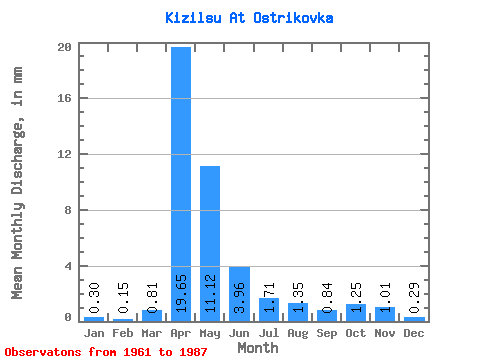
| Units: | m3/s |
| Statistic | Jan | Feb | Mar | Apr | May | Jun | Jul | Aug | Sep | Oct | Nov | Dec | Annual |
|---|---|---|---|---|---|---|---|---|---|---|---|---|---|
| Mean | 0.30 | 0.15 | 0.80 | 19.65 | 11.12 | 3.96 | 1.71 | 1.35 | 0.84 | 1.25 | 1.01 | 0.29 | 39.54 |
| Standard Deviation | 0.62 | 0.32 | 0.91 | 17.63 | 9.37 | 3.13 | 1.64 | 1.10 | 0.92 | 1.34 | 0.74 | 0.21 | 29.80 |
| Min | 0.00 | 0.00 | 0.00 | 3.02 | 2.15 | 0.21 | 0.08 | 0.01 | 0.00 | 0.15 | 0.12 | 0.00 | 10.21 |
| Max | 2.19 | 0.86 | 2.96 | 71.39 | 37.54 | 11.96 | 5.79 | 3.91 | 3.89 | 6.26 | 3.72 | 0.70 | 85.34 |
| Coefficient of Variation | 2.06 | 2.08 | 1.13 | 0.90 | 0.84 | 0.79 | 0.96 | 0.81 | 1.10 | 1.07 | 0.74 | 0.73 | 0.75 |
 Return to R-Arctic Net Home Page