|
|
|||||||||||||||||
| Point ID: 699 | Downloads | Plots | Site Data | Code: 07CE003 |
|
|
|||||||||||||||||
| Download | |
|---|---|
| Site Descriptor Information | Site Time Series Data |
| Link to all available data | |
| View: | Time Series | All |
| Units: | mm |
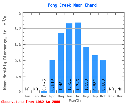
| Statistic | Jan | Feb | Mar | Apr | May | Jun | Jul | Aug | Sep | Oct | Nov | Dec | Annual |
|---|---|---|---|---|---|---|---|---|---|---|---|---|---|
| Mean | 0.04 | 0.82 | 1.48 | 1.72 | 1.75 | 1.14 | 0.93 | 0.81 | |||||
| Standard Deviation | 0.04 | 0.67 | 1.48 | 1.57 | 1.40 | 1.28 | 1.54 | 1.39 | |||||
| Min | 0.00 | 0.19 | 0.27 | 0.09 | 0.15 | 0.04 | 0.04 | 0.06 | |||||
| Max | 0.12 | 2.38 | 5.44 | 6.51 | 4.81 | 4.62 | 6.53 | 6.03 | |||||
| Coefficient of Variation | 0.77 | 0.82 | 1.00 | 0.91 | 0.80 | 1.13 | 1.66 | 1.71 |
 Return to R-Arctic Net Home Page