|
|
|||||||||||||||||
| Point ID: 699 | Downloads | Plots | Site Data | Code: 07CE003 |
|
|
|||||||||||||||||
| Download | |
|---|---|
| Site Descriptor Information | Site Time Series Data |
| Link to all available data | |
| View: | Time Series | All |
| Units: | m3/s |
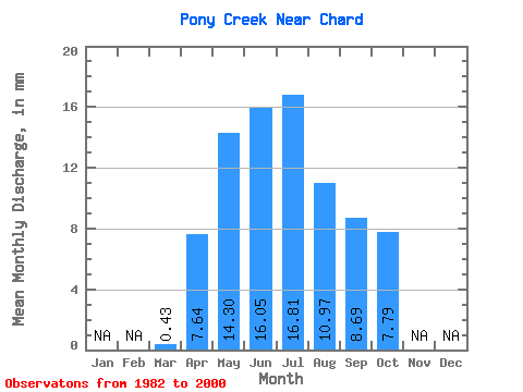
| Statistic | Jan | Feb | Mar | Apr | May | Jun | Jul | Aug | Sep | Oct | Nov | Dec | Annual |
|---|---|---|---|---|---|---|---|---|---|---|---|---|---|
| Mean | 0.43 | 7.63 | 14.29 | 16.05 | 16.81 | 10.97 | 8.69 | 7.79 | |||||
| Standard Deviation | 0.34 | 6.28 | 14.28 | 14.63 | 13.52 | 12.36 | 14.38 | 13.36 | |||||
| Min | 0.00 | 1.75 | 2.55 | 0.81 | 1.49 | 0.34 | 0.37 | 0.55 | |||||
| Max | 1.13 | 22.19 | 52.40 | 60.70 | 46.34 | 44.51 | 60.88 | 58.09 | |||||
| Coefficient of Variation | 0.77 | 0.82 | 1.00 | 0.91 | 0.80 | 1.13 | 1.66 | 1.71 |
 Return to R-Arctic Net Home Page