|
|
|||||||||||||||||
| Point ID: 6979 | Downloads | Plots | Site Data | Code: 11146 |
|
|
|||||||||||||||||
| Download | |
|---|---|
| Site Descriptor Information | Site Time Series Data |
| Link to all available data | |
| View: | Time Series | All |
| Units: | mm |
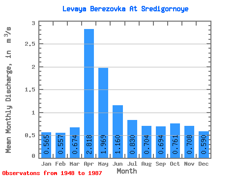
| Statistic | Jan | Feb | Mar | Apr | May | Jun | Jul | Aug | Sep | Oct | Nov | Dec | Annual |
|---|---|---|---|---|---|---|---|---|---|---|---|---|---|
| Mean | 0.56 | 0.56 | 0.67 | 2.82 | 1.97 | 1.16 | 0.83 | 0.70 | 0.69 | 0.76 | 0.71 | 0.59 | 0.98 |
| Standard Deviation | 0.21 | 0.23 | 0.39 | 1.06 | 1.09 | 0.56 | 0.37 | 0.31 | 0.25 | 0.20 | 0.19 | 0.19 | 0.28 |
| Min | 0.29 | 0.30 | 0.33 | 1.11 | 0.96 | 0.47 | 0.34 | 0.31 | 0.36 | 0.45 | 0.40 | 0.25 | 0.57 |
| Max | 1.37 | 1.36 | 2.12 | 5.12 | 6.69 | 3.04 | 1.92 | 1.61 | 1.48 | 1.27 | 1.09 | 1.05 | 1.94 |
| Coefficient of Variation | 0.38 | 0.40 | 0.58 | 0.38 | 0.55 | 0.48 | 0.45 | 0.44 | 0.35 | 0.26 | 0.27 | 0.33 | 0.28 |
 Return to R-Arctic Net Home Page