|
|
|||||||||||||||||
| Point ID: 6979 | Downloads | Plots | Site Data | Code: 11146 |
|
|
|||||||||||||||||
| Download | |
|---|---|
| Site Descriptor Information | Site Time Series Data |
| Link to all available data | |
| View: | Time Series | All |
| Units: | m3/s |
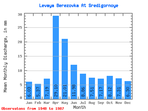
| Statistic | Jan | Feb | Mar | Apr | May | Jun | Jul | Aug | Sep | Oct | Nov | Dec | Annual |
|---|---|---|---|---|---|---|---|---|---|---|---|---|---|
| Mean | 6.03 | 5.42 | 7.20 | 29.10 | 21.01 | 11.98 | 8.86 | 7.51 | 7.16 | 8.12 | 7.31 | 6.30 | 123.48 |
| Standard Deviation | 2.29 | 2.18 | 4.16 | 10.94 | 11.60 | 5.74 | 3.94 | 3.33 | 2.54 | 2.10 | 1.94 | 2.07 | 34.56 |
| Min | 3.09 | 2.92 | 3.52 | 11.46 | 10.24 | 4.85 | 3.63 | 3.31 | 3.72 | 4.80 | 4.13 | 2.67 | 71.78 |
| Max | 14.62 | 13.22 | 22.62 | 52.87 | 71.38 | 31.39 | 20.48 | 17.18 | 15.28 | 13.55 | 11.26 | 11.20 | 243.51 |
| Coefficient of Variation | 0.38 | 0.40 | 0.58 | 0.38 | 0.55 | 0.48 | 0.45 | 0.44 | 0.35 | 0.26 | 0.27 | 0.33 | 0.28 |
 Return to R-Arctic Net Home Page