|
|
|||||||||||||||||
| Point ID: 6969 | Downloads | Plots | Site Data | Code: 11109 |
|
|
|||||||||||||||||
| Download | |
|---|---|
| Site Descriptor Information | Site Time Series Data |
| Link to all available data | |
| View: | Time Series | All |
| Units: | mm |
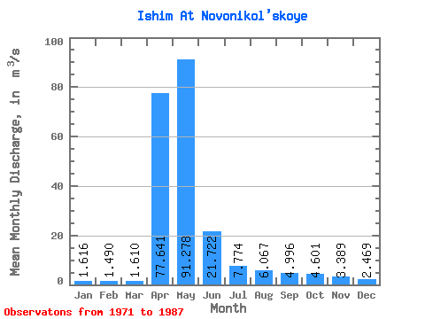
| Statistic | Jan | Feb | Mar | Apr | May | Jun | Jul | Aug | Sep | Oct | Nov | Dec | Annual |
|---|---|---|---|---|---|---|---|---|---|---|---|---|---|
| Mean | 1.62 | 1.49 | 1.61 | 77.64 | 91.28 | 21.72 | 7.77 | 6.07 | 5.00 | 4.60 | 3.39 | 2.47 | 20.52 |
| Standard Deviation | 1.38 | 1.38 | 1.51 | 198.00 | 144.72 | 37.51 | 8.69 | 5.34 | 3.84 | 3.27 | 2.46 | 1.85 | 31.25 |
| Min | 0.03 | 0.06 | 0.09 | 0.04 | 0.10 | 0.18 | 0.23 | 0.17 | 0.05 | 0.05 | 0.04 | 0.03 | 0.11 |
| Max | 3.64 | 4.38 | 4.77 | 604.00 | 414.00 | 122.00 | 24.70 | 17.60 | 10.80 | 10.50 | 6.75 | 6.39 | 89.01 |
| Coefficient of Variation | 0.85 | 0.93 | 0.94 | 2.55 | 1.58 | 1.73 | 1.12 | 0.88 | 0.77 | 0.71 | 0.73 | 0.75 | 1.52 |
 Return to R-Arctic Net Home Page