|
|
|||||||||||||||||
| Point ID: 6969 | Downloads | Plots | Site Data | Code: 11109 |
|
|
|||||||||||||||||
| Download | |
|---|---|
| Site Descriptor Information | Site Time Series Data |
| Link to all available data | |
| View: | Time Series | All |
| Units: | m3/s |
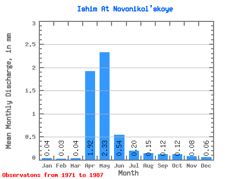
| Statistic | Jan | Feb | Mar | Apr | May | Jun | Jul | Aug | Sep | Oct | Nov | Dec | Annual |
|---|---|---|---|---|---|---|---|---|---|---|---|---|---|
| Mean | 0.04 | 0.03 | 0.04 | 1.72 | 2.09 | 0.48 | 0.18 | 0.14 | 0.11 | 0.10 | 0.07 | 0.06 | 5.54 |
| Standard Deviation | 0.03 | 0.03 | 0.03 | 4.39 | 3.31 | 0.83 | 0.20 | 0.12 | 0.09 | 0.07 | 0.06 | 0.04 | 8.43 |
| Min | 0.00 | 0.00 | 0.00 | 0.00 | 0.00 | 0.00 | 0.01 | 0.00 | 0.00 | 0.00 | 0.00 | 0.00 | 0.03 |
| Max | 0.08 | 0.09 | 0.11 | 13.38 | 9.48 | 2.70 | 0.56 | 0.40 | 0.24 | 0.24 | 0.15 | 0.15 | 24.01 |
| Coefficient of Variation | 0.85 | 0.93 | 0.94 | 2.55 | 1.58 | 1.73 | 1.12 | 0.88 | 0.77 | 0.71 | 0.73 | 0.75 | 1.52 |
 Return to R-Arctic Net Home Page