|
|
|||||||||||||||||
| Point ID: 6960 | Downloads | Plots | Site Data | Code: 11077 |
|
|
|||||||||||||||||
| Download | |
|---|---|
| Site Descriptor Information | Site Time Series Data |
| Link to all available data | |
| View: | Time Series | All |
| Units: | mm |
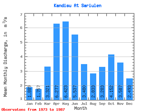
| Statistic | Jan | Feb | Mar | Apr | May | Jun | Jul | Aug | Sep | Oct | Nov | Dec | Annual |
|---|---|---|---|---|---|---|---|---|---|---|---|---|---|
| Mean | 1.89 | 1.76 | 3.32 | 6.28 | 6.42 | 5.54 | 3.48 | 2.83 | 3.28 | 4.15 | 3.59 | 2.49 | 3.75 |
| Standard Deviation | 0.58 | 0.59 | 0.82 | 1.07 | 1.17 | 0.98 | 0.65 | 0.43 | 0.42 | 0.48 | 0.59 | 1.06 | 0.32 |
| Min | 0.98 | 0.80 | 1.96 | 4.09 | 4.63 | 3.52 | 2.60 | 2.17 | 2.63 | 3.53 | 1.83 | 0.92 | 3.10 |
| Max | 2.75 | 3.08 | 4.38 | 8.01 | 9.15 | 7.08 | 4.79 | 3.54 | 4.16 | 5.31 | 4.41 | 4.51 | 4.44 |
| Coefficient of Variation | 0.31 | 0.33 | 0.25 | 0.17 | 0.18 | 0.18 | 0.19 | 0.15 | 0.13 | 0.12 | 0.17 | 0.42 | 0.09 |
 Return to R-Arctic Net Home Page