|
|
|||||||||||||||||
| Point ID: 6960 | Downloads | Plots | Site Data | Code: 11077 |
|
|
|||||||||||||||||
| Download | |
|---|---|
| Site Descriptor Information | Site Time Series Data |
| Link to all available data | |
| View: | Time Series | All |
| Units: | m3/s |
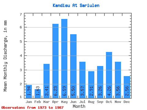
| Statistic | Jan | Feb | Mar | Apr | May | Jun | Jul | Aug | Sep | Oct | Nov | Dec | Annual |
|---|---|---|---|---|---|---|---|---|---|---|---|---|---|
| Mean | 1.94 | 1.64 | 3.41 | 6.23 | 6.59 | 5.50 | 3.57 | 2.91 | 3.26 | 4.26 | 3.56 | 2.56 | 45.38 |
| Standard Deviation | 0.59 | 0.55 | 0.85 | 1.06 | 1.20 | 0.98 | 0.67 | 0.44 | 0.42 | 0.49 | 0.59 | 1.08 | 3.86 |
| Min | 1.01 | 0.75 | 2.01 | 4.06 | 4.75 | 3.50 | 2.67 | 2.23 | 2.61 | 3.62 | 1.82 | 0.94 | 37.55 |
| Max | 2.82 | 2.88 | 4.49 | 7.96 | 9.39 | 7.03 | 4.92 | 3.63 | 4.13 | 5.45 | 4.38 | 4.63 | 53.74 |
| Coefficient of Variation | 0.31 | 0.33 | 0.25 | 0.17 | 0.18 | 0.18 | 0.19 | 0.15 | 0.13 | 0.12 | 0.17 | 0.42 | 0.09 |
 Return to R-Arctic Net Home Page