|
|
|||||||||||||||||
| Point ID: 6959 | Downloads | Plots | Site Data | Code: 11072 |
|
|
|||||||||||||||||
| Download | |
|---|---|
| Site Descriptor Information | Site Time Series Data |
| Link to all available data | |
| View: | Time Series | All |
| Units: | mm |
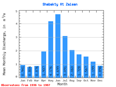
| Statistic | Jan | Feb | Mar | Apr | May | Jun | Jul | Aug | Sep | Oct | Nov | Dec | Annual |
|---|---|---|---|---|---|---|---|---|---|---|---|---|---|
| Mean | 0.94 | 0.80 | 0.88 | 1.94 | 4.18 | 4.70 | 3.09 | 2.06 | 1.73 | 1.57 | 1.20 | 0.90 | 1.84 |
| Standard Deviation | 0.34 | 0.28 | 0.25 | 0.76 | 1.22 | 2.32 | 1.74 | 1.20 | 0.86 | 0.66 | 0.35 | 0.31 | 0.50 |
| Min | 0.43 | 0.37 | 0.56 | 0.62 | 2.18 | 1.72 | 0.95 | 0.55 | 0.83 | 0.78 | 0.75 | 0.53 | 1.25 |
| Max | 1.66 | 1.26 | 1.39 | 3.80 | 6.66 | 11.20 | 7.86 | 5.93 | 4.34 | 3.43 | 1.90 | 1.82 | 3.10 |
| Coefficient of Variation | 0.36 | 0.35 | 0.29 | 0.39 | 0.29 | 0.49 | 0.56 | 0.58 | 0.50 | 0.42 | 0.29 | 0.35 | 0.27 |
 Return to R-Arctic Net Home Page