|
|
|||||||||||||||||
| Point ID: 6959 | Downloads | Plots | Site Data | Code: 11072 |
|
|
|||||||||||||||||
| Download | |
|---|---|
| Site Descriptor Information | Site Time Series Data |
| Link to all available data | |
| View: | Time Series | All |
| Units: | m3/s |
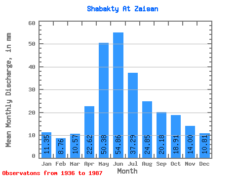
| Statistic | Jan | Feb | Mar | Apr | May | Jun | Jul | Aug | Sep | Oct | Nov | Dec | Annual |
|---|---|---|---|---|---|---|---|---|---|---|---|---|---|
| Mean | 11.35 | 8.84 | 10.57 | 22.61 | 50.37 | 54.86 | 37.28 | 24.85 | 20.18 | 18.91 | 14.00 | 10.80 | 261.69 |
| Standard Deviation | 4.04 | 3.07 | 3.04 | 8.86 | 14.73 | 27.09 | 20.98 | 14.46 | 10.11 | 7.90 | 4.10 | 3.74 | 70.98 |
| Min | 5.19 | 4.07 | 6.75 | 7.24 | 26.30 | 20.08 | 11.46 | 6.63 | 9.69 | 9.41 | 8.76 | 6.39 | 177.82 |
| Max | 20.02 | 13.85 | 16.77 | 44.37 | 80.34 | 130.77 | 94.82 | 71.53 | 50.67 | 41.38 | 22.18 | 21.95 | 440.35 |
| Coefficient of Variation | 0.36 | 0.35 | 0.29 | 0.39 | 0.29 | 0.49 | 0.56 | 0.58 | 0.50 | 0.42 | 0.29 | 0.35 | 0.27 |
 Return to R-Arctic Net Home Page