|
|
|||||||||||||||||
| Point ID: 6933 | Downloads | Plots | Site Data | Code: 10621 |
|
|
|||||||||||||||||
| Download | |
|---|---|
| Site Descriptor Information | Site Time Series Data |
| Link to all available data | |
| View: | Time Series | All |
| Units: | mm |
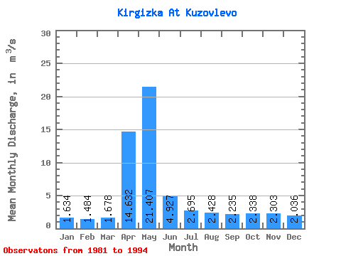
| Statistic | Jan | Feb | Mar | Apr | May | Jun | Jul | Aug | Sep | Oct | Nov | Dec | Annual |
|---|---|---|---|---|---|---|---|---|---|---|---|---|---|
| Mean | 1.63 | 1.48 | 1.68 | 14.63 | 21.41 | 4.93 | 2.69 | 2.43 | 2.23 | 2.34 | 2.30 | 2.04 | 5.12 |
| Standard Deviation | 0.92 | 0.75 | 0.78 | 8.67 | 12.43 | 2.39 | 1.38 | 1.24 | 1.11 | 1.08 | 1.30 | 1.16 | 1.65 |
| Min | 0.89 | 0.66 | 0.74 | 2.06 | 3.67 | 2.21 | 0.76 | 0.63 | 0.60 | 0.86 | 0.93 | 0.89 | 2.91 |
| Max | 3.68 | 3.11 | 3.33 | 30.40 | 43.60 | 9.87 | 4.86 | 4.27 | 3.97 | 3.97 | 4.70 | 4.30 | 8.77 |
| Coefficient of Variation | 0.56 | 0.50 | 0.46 | 0.59 | 0.58 | 0.48 | 0.51 | 0.51 | 0.49 | 0.46 | 0.56 | 0.57 | 0.32 |
 Return to R-Arctic Net Home Page