|
|
|||||||||||||||||
| Point ID: 6933 | Downloads | Plots | Site Data | Code: 10621 |
|
|
|||||||||||||||||
| Download | |
|---|---|
| Site Descriptor Information | Site Time Series Data |
| Link to all available data | |
| View: | Time Series | All |
| Units: | m3/s |
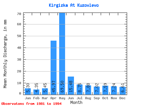
| Statistic | Jan | Feb | Mar | Apr | May | Jun | Jul | Aug | Sep | Oct | Nov | Dec | Annual |
|---|---|---|---|---|---|---|---|---|---|---|---|---|---|
| Mean | 5.30 | 4.39 | 5.45 | 45.97 | 69.49 | 15.48 | 8.75 | 7.88 | 7.02 | 7.59 | 7.24 | 6.61 | 195.73 |
| Standard Deviation | 2.97 | 2.21 | 2.53 | 27.23 | 40.34 | 7.51 | 4.47 | 4.02 | 3.47 | 3.50 | 4.08 | 3.77 | 63.02 |
| Min | 2.89 | 1.95 | 2.40 | 6.47 | 11.91 | 6.94 | 2.47 | 2.04 | 1.89 | 2.79 | 2.92 | 2.89 | 111.32 |
| Max | 11.95 | 9.20 | 10.81 | 95.51 | 141.53 | 31.01 | 15.78 | 13.86 | 12.47 | 12.89 | 14.77 | 13.96 | 335.46 |
| Coefficient of Variation | 0.56 | 0.50 | 0.46 | 0.59 | 0.58 | 0.48 | 0.51 | 0.51 | 0.49 | 0.46 | 0.56 | 0.57 | 0.32 |
 Return to R-Arctic Net Home Page