|
|
|||||||||||||||||
| Point ID: 6931 | Downloads | Plots | Site Data | Code: 10619 |
|
|
|||||||||||||||||
| Download | |
|---|---|
| Site Descriptor Information | Site Time Series Data |
| Link to all available data | |
| View: | Time Series | All |
| Units: | mm |
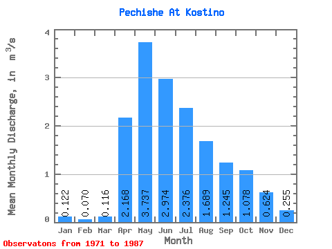
| Statistic | Jan | Feb | Mar | Apr | May | Jun | Jul | Aug | Sep | Oct | Nov | Dec | Annual |
|---|---|---|---|---|---|---|---|---|---|---|---|---|---|
| Mean | 0.12 | 0.07 | 0.12 | 2.17 | 3.74 | 2.97 | 2.38 | 1.69 | 1.25 | 1.08 | 0.62 | 0.26 | 1.33 |
| Standard Deviation | 0.13 | 0.10 | 0.13 | 1.30 | 2.72 | 1.84 | 2.00 | 1.29 | 0.74 | 0.54 | 0.41 | 0.22 | 0.76 |
| Min | 0.00 | 0.00 | 0.00 | 0.24 | 1.26 | 0.73 | 0.54 | 0.65 | 0.40 | 0.48 | 0.11 | 0.03 | 0.47 |
| Max | 0.53 | 0.35 | 0.44 | 4.60 | 11.50 | 6.93 | 9.58 | 5.93 | 3.47 | 2.49 | 1.76 | 0.92 | 3.03 |
| Coefficient of Variation | 1.04 | 1.42 | 1.12 | 0.60 | 0.73 | 0.62 | 0.84 | 0.76 | 0.59 | 0.50 | 0.66 | 0.86 | 0.57 |
 Return to R-Arctic Net Home Page