|
|
|||||||||||||||||
| Point ID: 6931 | Downloads | Plots | Site Data | Code: 10619 |
|
|
|||||||||||||||||
| Download | |
|---|---|
| Site Descriptor Information | Site Time Series Data |
| Link to all available data | |
| View: | Time Series | All |
| Units: | m3/s |
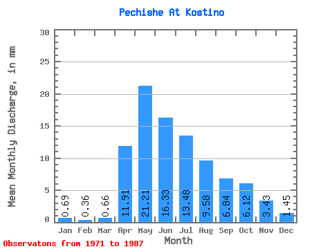
| Statistic | Jan | Feb | Mar | Apr | May | Jun | Jul | Aug | Sep | Oct | Nov | Dec | Annual |
|---|---|---|---|---|---|---|---|---|---|---|---|---|---|
| Mean | 0.69 | 0.36 | 0.66 | 11.90 | 21.20 | 16.33 | 13.48 | 9.58 | 6.83 | 6.11 | 3.43 | 1.45 | 89.16 |
| Standard Deviation | 0.72 | 0.51 | 0.73 | 7.17 | 15.46 | 10.10 | 11.33 | 7.30 | 4.04 | 3.05 | 2.27 | 1.25 | 50.81 |
| Min | 0.01 | 0.00 | 0.00 | 1.32 | 7.15 | 4.01 | 3.06 | 3.69 | 2.20 | 2.72 | 0.60 | 0.14 | 31.40 |
| Max | 3.01 | 1.81 | 2.50 | 25.26 | 65.25 | 38.06 | 54.35 | 33.65 | 19.06 | 14.13 | 9.66 | 5.22 | 202.67 |
| Coefficient of Variation | 1.04 | 1.42 | 1.12 | 0.60 | 0.73 | 0.62 | 0.84 | 0.76 | 0.59 | 0.50 | 0.66 | 0.86 | 0.57 |
 Return to R-Arctic Net Home Page