|
|
|||||||||||||||||
| Point ID: 6924 | Downloads | Plots | Site Data | Code: 10589 |
|
|
|||||||||||||||||
| Download | |
|---|---|
| Site Descriptor Information | Site Time Series Data |
| Link to all available data | |
| View: | Time Series | All |
| Units: | mm |
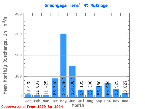
| Statistic | Jan | Feb | Mar | Apr | May | Jun | Jul | Aug | Sep | Oct | Nov | Dec | Annual |
|---|---|---|---|---|---|---|---|---|---|---|---|---|---|
| Mean | 13.47 | 11.70 | 11.43 | 88.94 | 302.47 | 150.07 | 34.19 | 36.30 | 55.18 | 66.40 | 38.93 | 19.63 | 69.06 |
| Standard Deviation | 3.77 | 2.92 | 2.38 | 35.44 | 62.77 | 70.49 | 12.69 | 16.47 | 33.17 | 27.41 | 17.90 | 5.53 | 11.53 |
| Min | 8.67 | 7.33 | 7.69 | 28.00 | 230.00 | 46.30 | 19.30 | 13.10 | 14.40 | 29.70 | 9.13 | 11.20 | 51.26 |
| Max | 20.60 | 17.50 | 16.10 | 149.00 | 484.00 | 282.00 | 66.60 | 72.90 | 117.00 | 123.00 | 78.80 | 29.70 | 100.27 |
| Coefficient of Variation | 0.28 | 0.25 | 0.21 | 0.40 | 0.21 | 0.47 | 0.37 | 0.45 | 0.60 | 0.41 | 0.46 | 0.28 | 0.17 |
 Return to R-Arctic Net Home Page