|
|
|||||||||||||||||
| Point ID: 6924 | Downloads | Plots | Site Data | Code: 10589 |
|
|
|||||||||||||||||
| Download | |
|---|---|
| Site Descriptor Information | Site Time Series Data |
| Link to all available data | |
| View: | Time Series | All |
| Units: | m3/s |
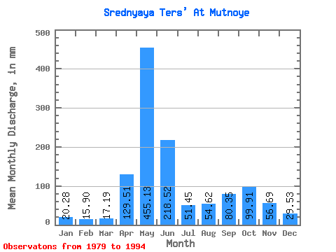
| Statistic | Jan | Feb | Mar | Apr | May | Jun | Jul | Aug | Sep | Oct | Nov | Dec | Annual |
|---|---|---|---|---|---|---|---|---|---|---|---|---|---|
| Mean | 20.27 | 16.03 | 17.19 | 129.51 | 455.06 | 218.52 | 51.44 | 54.61 | 80.35 | 99.90 | 56.69 | 29.53 | 1224.43 |
| Standard Deviation | 5.67 | 4.01 | 3.57 | 51.61 | 94.43 | 102.64 | 19.09 | 24.78 | 48.30 | 41.23 | 26.06 | 8.32 | 204.44 |
| Min | 13.04 | 10.05 | 11.57 | 40.77 | 346.03 | 67.42 | 29.04 | 19.71 | 20.97 | 44.68 | 13.29 | 16.85 | 908.87 |
| Max | 30.99 | 23.99 | 24.22 | 216.97 | 728.17 | 410.64 | 100.20 | 109.68 | 170.37 | 185.05 | 114.75 | 44.68 | 1777.75 |
| Coefficient of Variation | 0.28 | 0.25 | 0.21 | 0.40 | 0.21 | 0.47 | 0.37 | 0.45 | 0.60 | 0.41 | 0.46 | 0.28 | 0.17 |
 Return to R-Arctic Net Home Page