|
|
|||||||||||||||||
| Point ID: 6915 | Downloads | Plots | Site Data | Code: 10579 |
|
|
|||||||||||||||||
| Download | |
|---|---|
| Site Descriptor Information | Site Time Series Data |
| Link to all available data | |
| View: | Time Series | All |
| Units: | mm |
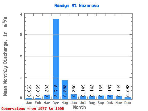
| Statistic | Jan | Feb | Mar | Apr | May | Jun | Jul | Aug | Sep | Oct | Nov | Dec | Annual |
|---|---|---|---|---|---|---|---|---|---|---|---|---|---|
| Mean | 0.06 | 0.07 | 0.20 | 3.72 | 0.90 | 0.23 | 0.15 | 0.14 | 0.17 | 0.20 | 0.14 | 0.09 | 0.51 |
| Standard Deviation | 0.04 | 0.05 | 0.26 | 1.81 | 0.60 | 0.16 | 0.12 | 0.09 | 0.12 | 0.09 | 0.07 | 0.06 | 0.14 |
| Min | 0.01 | 0.01 | 0.03 | 1.45 | 0.04 | 0.00 | 0.01 | 0.01 | 0.03 | 0.10 | 0.04 | 0.01 | 0.27 |
| Max | 0.14 | 0.17 | 1.01 | 8.19 | 1.89 | 0.47 | 0.35 | 0.29 | 0.44 | 0.45 | 0.28 | 0.24 | 0.71 |
| Coefficient of Variation | 0.62 | 0.68 | 1.26 | 0.49 | 0.67 | 0.70 | 0.79 | 0.62 | 0.68 | 0.45 | 0.52 | 0.67 | 0.26 |
 Return to R-Arctic Net Home Page