|
|
|||||||||||||||||
| Point ID: 6915 | Downloads | Plots | Site Data | Code: 10579 |
|
|
|||||||||||||||||
| Download | |
|---|---|
| Site Descriptor Information | Site Time Series Data |
| Link to all available data | |
| View: | Time Series | All |
| Units: | m3/s |
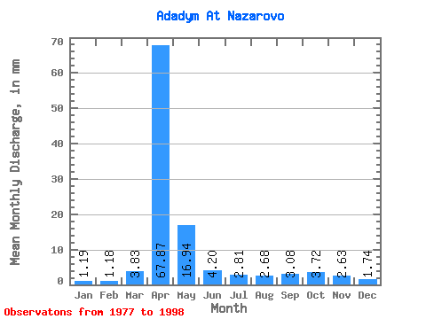
| Statistic | Jan | Feb | Mar | Apr | May | Jun | Jul | Aug | Sep | Oct | Nov | Dec | Annual |
|---|---|---|---|---|---|---|---|---|---|---|---|---|---|
| Mean | 1.19 | 1.19 | 3.83 | 67.86 | 16.93 | 4.20 | 2.82 | 2.68 | 3.09 | 3.73 | 2.62 | 1.74 | 113.73 |
| Standard Deviation | 0.74 | 0.81 | 4.83 | 33.00 | 11.28 | 2.94 | 2.23 | 1.67 | 2.11 | 1.66 | 1.37 | 1.17 | 30.02 |
| Min | 0.21 | 0.22 | 0.62 | 26.47 | 0.68 | 0.06 | 0.21 | 0.26 | 0.58 | 1.89 | 0.80 | 0.17 | 59.88 |
| Max | 2.64 | 2.92 | 19.05 | 149.50 | 35.64 | 8.58 | 6.60 | 5.47 | 8.03 | 8.49 | 5.11 | 4.53 | 158.56 |
| Coefficient of Variation | 0.62 | 0.68 | 1.26 | 0.49 | 0.67 | 0.70 | 0.79 | 0.62 | 0.68 | 0.45 | 0.52 | 0.67 | 0.26 |
 Return to R-Arctic Net Home Page