|
|
|||||||||||||||||
| Point ID: 6911 | Downloads | Plots | Site Data | Code: 10573 |
|
|
|||||||||||||||||
| Download | |
|---|---|
| Site Descriptor Information | Site Time Series Data |
| Link to all available data | |
| View: | Time Series | All |
| Units: | mm |
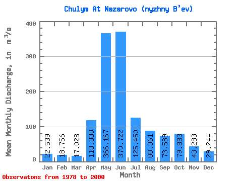
| Statistic | Jan | Feb | Mar | Apr | May | Jun | Jul | Aug | Sep | Oct | Nov | Dec | Annual |
|---|---|---|---|---|---|---|---|---|---|---|---|---|---|
| Mean | 22.54 | 18.76 | 17.03 | 118.34 | 366.17 | 370.72 | 125.45 | 88.36 | 73.59 | 79.88 | 43.28 | 29.24 | 112.78 |
| Standard Deviation | 5.70 | 4.79 | 4.39 | 54.56 | 80.31 | 116.38 | 46.07 | 32.91 | 28.70 | 42.75 | 16.62 | 9.58 | 21.63 |
| Min | 16.00 | 11.20 | 11.30 | 48.40 | 212.00 | 188.00 | 66.50 | 32.10 | 23.70 | 31.80 | 21.50 | 13.50 | 80.08 |
| Max | 31.40 | 29.00 | 28.10 | 233.00 | 565.00 | 587.00 | 228.00 | 155.00 | 121.00 | 207.00 | 73.50 | 47.30 | 160.72 |
| Coefficient of Variation | 0.25 | 0.26 | 0.26 | 0.46 | 0.22 | 0.31 | 0.37 | 0.37 | 0.39 | 0.54 | 0.38 | 0.33 | 0.19 |
 Return to R-Arctic Net Home Page